


وصف لـ AviNavi, navigation for pilots
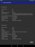
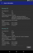
Aviation navigation made simple and affordable. All VFR, low-altitude IFR and instrument approach charts for the continental United States, with full flight planning, including support for airway navigation. Overlays for Nexrad, hazardous terrain, METARs and AIRMETS/SIGMETS improve flight safety, and detailed airport information (runways, frequencies, fuel etc) is at your fingertips.
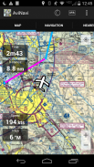
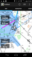
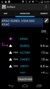
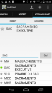
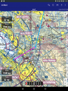
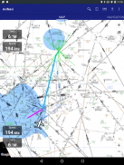
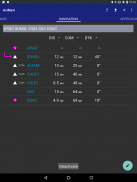
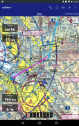
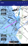
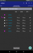
Use the moving map to search or select an airport, VOR, NDB or intersection and start direct-to navigation, or add to the flight plan. Alternatively enter the flight plan in text, e.g. KPAO SUNOL V334 SAC KSAC will load the full flight plan, including all airway navigation points.
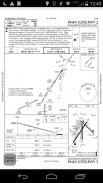
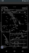
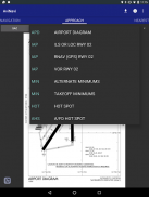
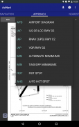
Instrument approach charts can be loaded by state or by route, e.g. ORD TO JFK will load all instrument charts for airports along this route. Approach charts include the airport diagram, STARS, DPs and minimums, as well as the legend.
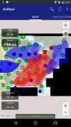
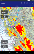
Nearby airports are shown in green, yellow or red to indicate whether or not those airports are likely reachable in a no-wind glide.
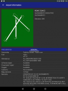
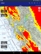
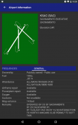
METAR, TAF, AIRMET, SIGMET, Prog charts, Convective Outlook and Wind are available as graphical and/or textual information. METARs and AIRMETS/SIGMETS can be overlayed on the map using the Layers button. Airport information shows METARs and TAFs in plain English, and tapping WX (or selecting Weather from the menu) will show Prog charts, Convective Outlook and Wind graphics that can be zoomed into.
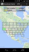
AviNavi is free to use with one VFR and one IFR map. For full continental coverage and approach charts, a $9.99 annual subscription is required.
جعل الطيران والملاحة بسيطة وبأسعار معقولة. كل VFR ومنخفضة الارتفاع IFR ونهج أداة الرسوم البيانية للولايات المتحدة القارية، مع تخطيط الرحلات الكاملة، بما في ذلك دعم للملاحة مجرى الهواء. تراكب لNEXRAD والتضاريس الخطرة، METARs وAIRMETS / SIGMETS تحسين سلامة الطيران، والمعلومات المطار مفصلة (مدارج، الترددات، وما إلى ذلك وقود) هو في متناول يدك.
استخدام خريطة التحرك للبحث أو اختيار المطار، VOR، NDB أو تقاطع والبدء مباشرة إلى التنقل، أو إضافة إلى خطة الطيران. وبدلا من الدخول في خطة الطيران في النص، على سبيل المثال، سيتم تحميل KPAO SUNOL V334 SAC KSAC خطة الرحلة كاملة، بما في ذلك جميع نقاط مجرى الملاحة.
الرسوم البيانية نهج أداة يمكن تحميلها من قبل الدولة أو من قبل الطريق، وعلى سبيل المثال وأورد جون كنيدي للتحميل جميع الخرائط أداة للمطارات على طول هذا الطريق. وتشمل المخططات نهج مخطط المطار، النجوم، المرحلين والحد الأدنى، وكذلك أسطورة.
وترد المطارات القريبة باللون الأخضر، الأصفر أو الأحمر للإشارة إلى ما إذا كان هذه المطارات هي على الأرجح يمكن الوصول إليها في أنسل من أي الرياح.
METAR، TAF، AIRMET، SIGMET، الرسوم البيانية بروغ، كما تتوفر الرسومية و / أو المعلومات النصية الحمل الحراري Outlook و الرياح. / SIGMETS يمكن تراكب إعلان METARs وAIRMETS على الخريطة باستخدام زر الطبقات. وتشير المعلومات المطار METARs وTAFs في سهل الانجليزية، وسوف التنصت WX (أو اختيار الطقس من القائمة) تظهر الرسوم البيانية بروغ، الحمل الحراري Outlook و الرسومات الرياح التي يمكن أن يكون أسرع في.
AviNavi غير تتردد في استخدامها مع VFR واحد وخريطة IFR واحد. لتغطية ونهج القارية كامل الرسوم البيانية، لا بد من الاشتراك السنوي 9،99 $.
AviNavi, navigation for pilots - إصدار 4.5.7
(08-01-2024)
AviNavi, navigation for pilots - معلومات APK
نُسخة APK: 4.5.7الحزمة: com.bbflight.avinaviتطبيقات من الفئة نفسها
قد يعجبك أيضًا...


